On this dialog you are to provide the data for port-fixed attributes relevant for a mooring arrangement: bollards and port-fixed fenders.
The horizontal coordinates for bollards and fenders are to be provided in (Easting, Northing) or (Longitude, Latitude) dependent on the choice of map projection. If the domain file has projection Local coordinates, you will be forced to provide all horizontal positions with respect to this projection. The vertical coordinate is positive upwards from the water level.
The XYZ data for bollards and fenders can be inserted record-by-record, but can also be imported from an (.xyz) file, where the following delimiter choices are supported: space, comma and tab.
For each fender you furthermore have to provide a direction in which the fender force works, as well as associating the spatial fender with one of the earlier declared fender material profiles.
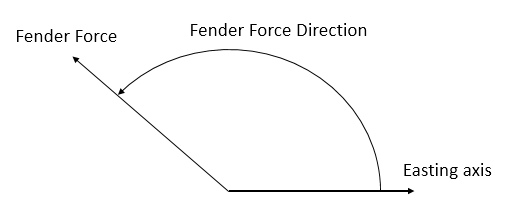
The fender force must point towards the vessel and it’s direction is defined as counter-clockwise positive from Easting axis (going to), see Figure 1.4.

Figure 1.4 Definition of fender force direction
The symbol orientation for bollards and fender can be controlled by the value for ‘Symbol orient’ (90° by default for bollards and 0° by default for fenders). The port coordinate system is in the Domain dialog - see Section 1.1.These symbol orientations have no computational impact, it is only for making the illustration more realistic (symbol orientation relative to the domain).