First of all, you have to indicate whether the wave data file is output from the simulation of stationary conditions (i.e. that the data file will have only one time step) or quasi-stationary conditions (i.e. several time steps have been saved to the wave data file).
Then, you have to specify the path and the name of the wave data file. They may be typed directly or found browsing the disk by clicking the mouse on the button to the right of the Data File entry in the menu. The wave data may have been generated as the output from a wave simulation with MIKE 21 Spectral Wave (SW) using a dfs2 bathymetry. After the wave data file has been selected, you must indicate which items in it correspond to the wave height, the direction of wave propagation and the wave period.
The wave data file must contain at least two items (wave height and direction of propagation) or more than the three items (wave height, period and direction) required for the calculation of transport rates. In either case it is possible to choose a user-specified wave period rather than reading it from the wave data file.
The sediment transport rates will only be calculated in the area where wave and current data exist, i.e. in the region which is common to the hydrodynamic and wave model grids. Therefore, the user should carefully check that the area of interest for the transport computations is covered by both grids.
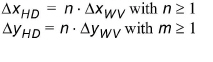
The grid spacing(s) of the wave data file does/do not need to be equal to the spacing(s) used for the hydrodynamic model grid. However, the grid spacing in the hydrodynamic data must be an integer number of times the spacing in the wave grid, both in the x- and the y-directions. The proportionality factors n and m need not to be equal.
(4.1)
![]()