Export
Export to Shapefile
Export to MIKE 11
Export Preprocessed DEM to dfs2
The majority of georeferenced model features defined in MIKE HYDRO Basin can be exported to Shapefiles.
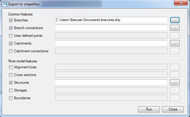
The export option is activated through ‘Export to Shape files', which opens the dialogue as presented in Figure 15.3.
Figure 15.3 Export MIKE HYDRO Data to Shapefile dialogue
The dialogue contains two groups of data; 'Common features' which are features that are also used by other modules than Basin, and 'Basin Module Features' which are module specific features used only in the specific MIKE HYDRO module.
Export the requested model data by activating the checkbox in front features that should be processed and specify a shapefile names for the individual features. Use the file selection button '…' for specifying the output shapefile names.
After completing selections and filename specifications, press the 'Run' button to execute the export of model data to shapefiles. Press 'Close' to stop the conversion or to close the dialogue.
Shapefile content from Export of MIKE HYDRO features will include the following information:
|
MIKE HYDRO features |
Shape type |
Key variables to export as shapefile attributes |
Attribute name |
Attribute type |
|---|---|---|---|---|
|
Branches |
River shapes (Polylines) |
Branch name Identifier Topo-ID Start Chainage End Chainage Flow direction Branch Type |
BR_BrName BR_ID BR_TopoID BR_StartCh BR_EndCh BR_FlowDir BR_Type |
Text Text Text Double Double Short integer Short integer |
|
Branch connections |
Connecting lines (Polyline) |
Branch name Upstr. Type Upstr. Branch name Upstr. Chainage Upstr. Storage ID Downstr. Type Downstr Branch name Downstr. Chainage Downstr. Storage ID |
BC_BrName BC_UpsType BC_UpsName BC_UpsCh BC_UpsStID BC_DwsType BC_DwsName BC_DwsCh BC_DwsStID |
Text Short integer Text Double Text Short integer Text Double Text |
|
User defined chainages |
Points |
Branch name Chainage |
UDC_BrName UDC_Ch |
Text Double |
|
Catchments |
Catchment shapes (polygons) |
Name Use Polygon Area Catchment Area Rainfall-Runoff model Branch Chainage |
Cat_Name Cat_AreSel Cat_Area Cat_RRMod Cat_BrName Cat_Ch |
Text Short integer Double Short integer Text Double |
|
Catchment connections |
Connection (Polyline) |
Catchment name Branch name Chainage Upstream Ch Downstream ch |
CC_CatName CC_BrName CC_Ch CC_UpsCh CC_DwsCh |
Text Text Double Double Double |
|
River Nodes |
Node locations (Points) |
Branch name Chainage Identifier Type |
RN_BrName RN_Ch RN_ID RN_Type |
Text Double Text Short integer |
|
Water Users |
User Locations (Points) |
Name Type |
WU_Name WU_Type |
Text Short integer |
|
Water User Connections |
Polyline |
Water user name Identifier Supply Branch name Supply Chainage Supply priority Return Branch name Return Chainage |
WUC_Name WUC_ID WC_SuppName WC_SuppCh WC_Priorit WC_RetName WC_RetCh |
Text Text Text Double Long integer Text Double |
|
Reservoirs |
Reservoir locations (Points) |
Name Identifier Branch name Chainage Type |
RES_ResName RES_ID RES_BrName RES_Ch RES_Type |
Text Text Text Double Short integer |
|
Hydro power |
Hydro power locations (Points) |
Name Identifier Reservoir Branch name Chainage |
HP_HPName HP_ID HP_Reserv HP_BrName HP_Ch |
Text Text Text Text Double |
The Export to MIKE 11 option target the River module of MIKE HYDRO allowing to create MIKE 11 river models from MIKE HYDRO River.
More details on the Export to MIKE 11 option can be found in MIKE HYDRO River documentation.

Export Preprocessed DEM to dfs2
If Digital Elevation Model (DEM) is included in MIKE HYDRO for use in catchment and river delineation it is requirement to make a preprocessing of the DEM prior to these operations. This export function enable an option for saving the preprocessed data from this process in to a dfs2 file for general information about the preprocessing results.
![]()