In most applications, the Basin module is used only to calculate flows, not water levels. The Basin module is not a hydraulic model and thus cannot be used for proper flood modelling. The River module is more suited for such purposes. However, Water level calculations can be done in the Basin module. If the Water Quality module has been enabled water level calculations are required.
Two methods are available for Water level calculations:
· Rating curve approach (Q-h table)
Both apply for steady-state flow and are thus approximations, but they are usually reasonable estimates as long as the water level does not change rapidly (e.g. during a flood). The items in the dialogue window change depending on the option chosen.
When the Rating Curve approach is used, it looks up the water level in a user specified Q-h table. The table must cover the range of discharges encountered during a simulation.
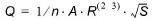
Where n is the Manning’s number n, A is the cross-sectional area, S is the water surface slope, R is the resistance radius:
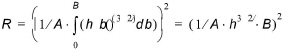
assuming a rectangular cross-section with width B, and h(b)=h
so R can be written as:

and

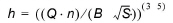
Thus water level can be computed as:
The parameters to be specified for the Manning formula are already specified elsewhere for the River Module, but must be specified here for the Basin Module:
Manning’s number
Here the Manning number must be specified.
Slope
Here you can enter the slope. Generally, it is a good approximation to equate surface and channel slope.
Max level (optional)
Optionally, you can also specify a maximum water depth up to which results from the Manning formula are accepted. If you specify such a (non-zero) value, water levels will never exceed it.
Width
Cross section width B, used in the water level calculations. It is assumed that the cross-section is rectangular.
![]()