Soil and runoff
In the Soil and Runoff section, the parameters for different combinations of soil type and runoff models are specified.
To create a new model click on the ‘Append’ button, designated with the symbol  . A new line appears in the window displayed at the bottom of the screen. You can specify a Name for the new soil type, i.e. the name of the dominant soil type in the soil profile. The Soil model and Runoff model inputs can be entered in the relative sections.
Alternatively, predefined soil and runoff models can be loaded from a template file by clicking on the ‘Load template’ button,  , and browsing to the specific template file. An existing template used in another MIKE HYDRO model can also be used, by clicking on ‘Import existing’,
  , and browsing to the previously created .mhydro file.
To delete the currently displayed crop type information click on ‘Delete’:  .
.
To switch between the different soil and runoff models, click on the lines relative to different crop types in the tab in the lower part of the Tabular view.
Soil model
The Soil model, also referred to as soil water model, keeps track of the water flow between different layers in the soil profile and the time-varying water content in each layer (see Figure 8.5). The main task of the soil water model is to keep track of the amount of soil water available for soil evaporation and crop transpiration at any time during the simulation. The soil water content may also be used by the irrigation module to determine the irrigation demand.
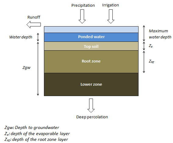
Figure 8.5 Schematisation of the Soil Water models. Each model uses
a different number of layers
You can chose between three soil water model types:
· FAO 56 soil water model. The FAO 56 soil water model is a simple water balance based model that follows the recommendations provided in FAO 56 /1/ for use with the dual crop coefficient method.
· ZIMsched soil water model. The ZIMsched soil water model is one step more complex than the FAO 56 soil model. It simulates the water balance in the unsaturated soil column in three compartments, instead of the two of FAO 56.
· ZIMsched for Rice field soil water model. The ZIMsched for Rice field, a soil water model for rice crops, is an extension of the ZIMsched model with an additional storage on the ground surface. This allows water to be stored on the ground surface during growth of rice.
See ‘Irrigation’ (Section A.3) in Appendix A for more detailed information on these models.
FAO 56 soil water model
In the FAO 56 soil water model dialogue, the required soil properties are defined, and, here, the following parameters need to be specified (see also Table 8.1 for suggested representative values):
Soil moisture contents
· Initial. This is the starting soil moisture content at the beginning of the crop season [0-1]. The Initial soil moisture content is set for the Top soil and the Root zone. For the Lower zone the initial soil moisture is by default, at Field capacity.
· Field capacity. This is the maximum water content held by the soil against gravity [0-1]. Water cannot be retained in the top soil and the root zone layer when the water is above field capacity, as it will drain away under gravity. Soil moisture below field capacity is available for evapotranspiration until the soil moisture reaches wilting point.
· Wilting point. This is the lowest soil moisture content at which plants can draw water from the top soil and the root zone layers [0-1].
Other parameters are:
· Porosity.This is the maximum soil moisture content that the soil can contain [0-1].
· Depth of evaporable layer. This is the depth of the top soil layer from which evaporation occurs [m].

Example
The amount of water in a soil column depends on the soil moisture content and the length of the soil column. If the field capacity is 0.15, the wilting point is 0.05, and the length of the root zone is 0.5 meter, then the available amount of water for transpiration is: 500 mm.
Table 8.1 The representative soil property values and maximum depletion by evaporation for an evaporation layer of 0.1 m
|
Soil type
|
Field capacity
|
Wilting point
|
Difference
|
Max. depletion by evaporation [mm]
|
|
Sand
|
0.07-0.17
|
0.02-0.07
|
0.05-0.11
|
6-12
|
|
Loamy sand
|
0.11-0.19
|
0.03-0.10
|
0.06-0.12
|
9-14
|
|
Sandy loam
|
0.18-0.28
|
0.06-0.16
|
0.11-0.15
|
15-20
|
|
Loam
|
0.20-0.30
|
0.07-0.17
|
0.13-0.18
|
16-22
|
|
Silt loam
|
0.22-0.36
|
0.09-0.21
|
0.13-0.19
|
18-25
|
|
Silt
|
0.28-0.36
|
0.12-0.22
|
0.16-0.20
|
22-26
|
|
Silt clay loam
|
0.30-0.37
|
0.17-0.24
|
0.13-0.18
|
22-27
|
|
Silt clay
|
0.30-0.42
|
0.17-0.29
|
0.13-0.19
|
22-28
|
|
Clay
|
0.32-0.40
|
0.20-0.24
|
0.12-0.20
|
22-29
|
ZIMsched soil water model
The parameters for the ZIMsched soil water model are the same as those of the FAO 56 model. Additionally, two extra parameters need to be specified:
· Sat. hydraulic conductivity. The saturated hydraulic conductivity is also called the saturated drainage coefficient [mm/h]. Since it is known that the drainage of water from an unsaturated zone diminishes with diminishing soil moisture, water may not drain instantaneously from the time when the water is above field capacity. In such cases water will be available for transpiration for a short period depending on the magnitude of the saturated drainage coefficient.
· Depth to groundwater. The unsaturated soil zone extends from the ground surface to the groundwater table [m]. Based on the depth of the top soil and the root zone layers, the lower soil layer can be calculated. From this zone deep percolation to the groundwater takes place using the same drainage formula as for the root zone layer.
ZIMsched for Rice field soil water model
The ZIMshed for Rice field soil water model requires an extra parameter describing the maximum water depth that can be stored on the ground (often called detention storage):
· Max water depth. The maximum water depth [m] specifies the maximum water depth that can be held back on the ground surface before surface runoff takes place. From this storage water can evaporate and infiltrate into the top soil storage.
Runoff model
When it rains on the ground surface, a certain amount of the water may run off, either as surface flow or as subsurface flow or both. The percolation to groundwater is calculated whether a surface runoff model is included or not. The task of the Runoff model is to calculate the surface flow part of the total runoff. Surface runoff may occur either when it rains, when the crop is over-irrigated, or when a combination of both happens (more details about the Runoff Model can be found in Appendix A, Section A.3.5).
When the runoff model option is selected, an ‘f’ direct surface flow runoff is calculated and subtracted from the rainfall. The remaining rainfall (called the net rainfall, PN) is input to the soil column water balance. If PN together with the applied irrigation cannot be stored in the soil (or on the ground surface, in case of rice fields), additional surface flow runoff may occur. If the irrigation node is connected to the river network, the calculated surface runoff will return through the return flow channel to the river. If the irrigation node is not connected to a river with a return flow channel, the water will be lost from the model.
When the runoff model option is not selected, the total rainfall enters the soil column water balance. If the rainfall and/or the irrigation input cannot be stored in the soil surface (or on the ground surface, in case of rice fields), the surplus water is considered surface runoff and removed from the field. However, the surface runoff is not returned to the river, but lost from the model, even if the irrigation node is connected to a river with a return flow channel.
There are four Runoff model options available:
· None
· Linear runoff model, available for all crops (i.e. for all types of Soil model)
· Modified SCS runoff model, available for all crops except rice (i.e. for all types of Soil models except the ZIMsched for Rice field)
· Modified SCS for Rice field runoff model, available only in combination with the ZIMshed for Rice field Soil model
None (No runoff model)
If the ‘None’ runoff model is selected, the rainfall enters the soil column water balance. if rainfall and/or irrigation cannot be stored in the soil surface, the surplus water is removed from the field and the model.
Linear runoff model
The Linear runoff model assumes a linear relationship between the rainfall [mm] and the amount of surface runoff. The runoff will be generated according to two specified linear formulas, valid when the accumulated rainfall is above or below a given threshold.
The parameters for the linear runoff model are:
· When Rainfall is lower than. It is the threshold of the accumulated rainfall [mm] on the field below which runoff occurs. In this case the runoff follows the formula specified in the line below:
Runoff = linear coefficient [ ] (fraction to be inserted in the formula) x Rainfall + constant (to be inserted in the formula) in [mm]
· When Rainfall is greater than. It displays the threshold of the accumulated rainfall [mm] on the field above which runoff occurs. If the rainfall is above the threshold, the runoff follows the formula specified in the line below:
Runoff = linear coefficient [ ] (fraction to be inserted in the formula) x Rainfall + constant (to be inserted in the formula) in [mm]
Regardless of the specified parameters, the runoff will never be negative.

Note: When including the Linear runoff model, for any crop including rice, setting both coefficients in the linear equation to zero will have the same effect as not including a surface runoff model. In that case, any excess surface water will to return to the river.
Modified SCS runoff model
When the Modified SCS runoff model is selected, the surface runoff is estimated using the Soil Conservation Service (SCS) storm flow equation (USDA, 1985) /2/ as modified by Schulze (1995) and used in the ACRU agrohydrological simulation model in South Africa (cf. Modified SCS under Section A.3.5.2 in Appendix A for further details).
The parameters to be specified for the Modified SCS runoff model are:
· Soil moisture integration depth. The soil moisture integration depth [m] which has an influence on the infiltration losses in the modified SCS model.
· Coefficient of initial abstraction. This coefficient determines also the infiltration losses.
Modified SCS for Rice field runoff model
The input parameters for the Modified SCS for Rice field runoff model are the same as those for the Modified SCS.
The difference between the Modified SCS for Rice field model and the Modified SCS model is that the space (storage) between the maximum ponded water depth (see the ZIMsched for Rice field model section) and the actual water depth is also taken into account in the calculation of the water volume of the potential maximum water retention of the soil, S.
In addition, excess water above the maximum ponded water depth at the end of a time step is added to the already calculated surface runoff (this can only occur when a specified irrigation application is used).