GeoScene3D is a visualisation tool widely used in Denmark for displaying geologic data in a dynamic 3D environment. It has been adapted to read MKE SHE results. For more information on GeoScene3D, visit www.i-gis.dk (unfortunately mostly written in Danish).
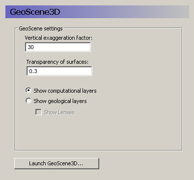
The GeoScene3D dialogue appears when you have a licensed copy of GeoScene3D. The dialogue provides a link to the GeoScene3D program for viewing the preprocessed model setup. The preprocessed data does not include any transient or time data. So, GeoScene3D only shows stationary data.
Vertical exaggeration factor - In most models, the lateral extent is several orders of magnitude greater than the vertical extent. Thus, without a vertical exaggeration factor, the model view will be too thin to be useful. A vertical exaggeration of 10 to 30 will typically give you a good looking model that accentuates the vertical differences.
Transparency of surfaces - The transparency factor allows you to see through the model surfaces. This gives you a better feeling of what is happening below or above the surface that you are looking at.
Show computational layers - In this case, the model’s computational layers will be visible and selectable in the GeoScene3D interface.
Show geological layers - In this case, the specified conceptual geologic layers will be visible and selected in the GeoScene3D interface.
Show lenses - If you select to show lenses, then they will be displayed on top of the geologic layers.
![]()