GeoScene3D is a visualisation tool widely used in Denmark for displaying geologic data in a dynamic 3D environment. It has been adapted to read MKE SHE results. For more information on GeoScene3D, visit www.i-gis.dk (unfortunately mostly written in Danish).
The GeoScene3D dialogue appears when you have a licensed copy of GeoScene3D. The dialogue provides a link to the GeoScene3D program for viewing the model results.
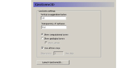
Vertical exaggeration factor - In most models, the lateral extent is several orders of magnitude greater than the vertical extent. Thus, without a vertical exaggeration factor, the model view will be too thin to be useful. A vertical exaggeration of 10 to 30 will typically give you a good looking model that accentuates the vertical differences.
Transparency of surfaces - The transparency factor allows you to see through the model surfaces. This gives you a better feeling of what is happening below or above the surface that you are looking at.
Show computational layers - In this case, the model’s computational layers will be visible and selectable in the GeoScene3D interface.
Show geological layers - In this case, the specified conceptual geologic layers will be visible and selected in the GeoScene3D interface.
Show lenses - If you select to show lenses, then they will be displayed on top of the geologic layers.
Use all time steps - The default action is to display time varying data with all of the time steps
Show every __ time step - However, if your data files are visualized too slowly, then you can reduce the number of time steps being shown.
![]()