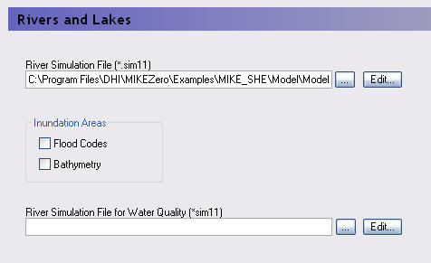
In the Rivers and Lakes dialogue (below) you can link MIKE SHE to a MIKE 11 or a MIKE Hydro River model.
For MIKE 11, the River Simulation File (.sim11) is the main MIKE 11 simulation file, which contains the file references to all the files used in the MIKE 11 model. For MIKE SHE, the primary MIKE 11 files are:
· the simulation control file (.sim11),
· the river network file (.nwk11),
· the cross-section database (.xns11),
· the boundary condition file (.bnd11) and
· the hydrodynamic setup file (.hd11).
For MIKE Hydro River, the main simulation file is the .hydro file.
In the Rivers and Lakes dialogue, there are two Inundation Areas options These options are always available for input, but are only used if you have selected specific options in the MIKE SHE Links dialogue in the Network Editor. These options are
· Flood codes - a map used for the direct inundation of flooded areas in MIKE SHE based on water levels in , and
· Bathymetry - a detailed topography file that can be used to modify the defined topography with a more detailed flood plain topography in areas where Flood Codes have been defined.
Integrating a MIKE SHE and a MIKE Hydro River model is not very different from establishing a stand-alone MIKE Hydro River model and a stand-alone MIKE SHE model. In principle there are three basic set-up steps:
1. Establish a MIKE Hydro River hydraulic model as a stand-alone model and make a performance test and, if possible, a rough calibration using prescribed inflow and stage boundaries. You can also specify a default groundwater table (e.g. MIKE SHE’s initial groundwater level) and leakage coefficients for any leakage calculations.
2. Establish a MIKE SHE model that includes the overland flow component and (optionally) the saturated zone and unsaturated zone components. An SZ drainage boundary can be used to prevent excessive surface flows in low lying areas and the river flood plain.
3. Couple MIKE SHE and MIKE Hydro River by defining branches (reaches) where MIKE Hydro River should interact with MIKE SHE. Modify your MIKE SHE and MIKE Hydro River models so that they work together properly. For example, by removing the specified groundwater table in MIKE Hydro River and adjusting your SZ drainage elevations if you used these in Step 2.
Detailed information on developing your surface water model, specifying flow on flood plains, and coupling to MIKE Hydro River is in the chapter Surface Water (V1 p. 97).
Additional documentation on MIKE Hydro River can be found in the MIKE Hydro River User Guide.
![]()