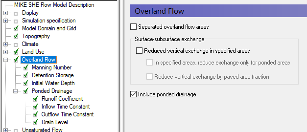
Ponded drainage is specified by selecting the Include ponded drainage checkbox in the Overland Flow dialog. This will activate the Ponded Drainage dialog and the default additional data tree items.
The options for defining OL Drainage are selected in the Ponded Drainage dialog:
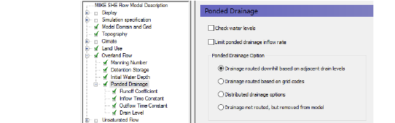
There are two check box options for controlling the OL Drainage:
Check water levels
If the destination of the OL drainage is a river or an internal depression, then it will have a water level. If you chose the option to Check water levels, then the drainage will not be added to the destination if the water level in the destination is equal to or higher than the water level in the drain.
The source water level for the comparison is calculated based on the OL Drain level plus the depth of water in the OL Drain storage in the time step.
Limit inflow rate to OL Drain Storage
The amount of ponding that is removed in one time step is a function of the leakage coefficient. Usually the leakage coefficient is large enough to ensure that all ponding is removed in the current time step. However, often the conveyance through the drain is restricted, such as a culvert. This is addressed by an option for specifying a maximum discharge rate into the drain. The maximum inflow rate can be specified as a constant value or a distributed (dfs2) value. With an Extra Parameter option, the maximum discharge rate can be time varying (dfs2).
The maximum inflow rate can be used to control the inflow to the OL drainage system. At every time step, the available drainage volume will be checked against the maximum drainage rate. Thus, ponded water will be retained on a grid cell and drained at a controlled rate into the drainage system. While the water is ponded it will be subject to infiltration and ET. The rate of leakage below the cell can be controlled by the Surface-Subsurface Leakage Coefficient (V1 p. 269).

Note: Prior to Release 2017, this was called the “Max Storage Change Rate” with Item Type [Storage Change Rate] and default EUM Units of [mm/hour]. There is no automatic backwards compatibility conversion for this. If an existing model uses this option, a uniform value has to be manually converted to the new units - Default units [m3/s]. If a dfs2 file is used, the Item Type also needs to be converted to the new Item Type [Discharge].
Destination options for OL Drainage
The default option is to calculate the drainage destination by looking downhill until a river, boundary or local depression is reached. The elevation for calculating this is the Drain Level. Typically, this will be the same as the Topography (default). However, it could be different, for example, in urban areas where the drain level might be based on sewer inverts.
If Drain codes are selected, then the Drain Levels are used only within the cells that have the same Drain code.
![]()