Snow melting and freezing
Snow melts in response to several climatic conditions, including air temperature, sun shine (solar radiation), the heat content of rain, and the heat transfer from condensing moisture in the air.
Snow moisture content
It is well known that melting snow does not immediately genenerate runoff. Rather, the snow gradually becomes wetter, like a sponge, until liquid water starts to drain out of the snow pack. If the temperature drops below freezing again, the liquid water will re-freeze. In MIKE SHE, this is conceptualized as two seperate snow storages - dry (or frozen) snow storage and wet (or liquid) snow storage.
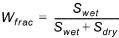
Snow melt occurs by converting dry snow to wet snow. Surface runoff occurs when the ratio of dry to wet snow storage reaches a user specified maximum - the maximum wet snow storage fraction, where the wet snow storage fraction, Wfrac, is calculated by
(22.4)
where Swet and Sdry are the wet and dry snow storages respectively.
Air temperature melting
If the air temperature is above the threshold melting temperature, then the snow will begin to melt and the snow storage will be reduced by
(22.5) 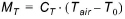
where MT is the rate of melting due to the air temperature, CT is the degree-day factor for snow melting (e.g in units of mm/day/C degree), Tair is the air temperature of the cell, and T0 is the threshold melting temperature. The air temperature melting will be positive if the air temperature is above the threshold temperature and negative if it is below. Thus, if the air temperature falls below the threshold melting temperature, then wet snow will be reconverted back to dry snow.
Note In MIKE SHE, the degree-day factor is a time varying, spatially distributed value. This allows you to calibrate your snow melt over the winter season as the snow properties (e.g. albedo, density, etc) change.
Radiation melting
Solar radiation will cause the snow to melt at a rate proportional to the amount of incoming radiation. On cloudy days, the radiation intensity will be less, but still non-zero. Thus,
(22.6) 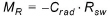
where MR is the rate of melting due to incoming short wave radiation, Crad is the radiation melting factor for snow melting (e.g in units of mm/kJ/m2), Rsw is the amount of incoming solar radiation (e.g. in units of kJ/m2/hour).
Energy melting
The condensation of moist air on snow and the heat released from liquid rain as it cools are important contributors to snow melt. Even though these energy sources are not physically simulated, the following linear relationship allows these processes to be included.
(22.7) 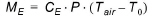
where ME is the rate of melting due to the energy in liquid rain, CE is the energy melting coefficient for the energy in liquid rain (e.g in units of mm/mm rain/C degree), Tair is the air temperature of the cell, and T0 is the threshold melting temperature.
Energy melting only occurs if the air temperature is above the threshold melting temperature. In other words, the energy melting is aways positive. The temperature of the rain is assumed to be the same as the air temperature.
Note The energy melting coefficient is a constant value for the entire model.
Snow balance
If the air temperature is above the threshold melting temperature, then dry snow storage will be reduced (converted to wet snow) by combining the three melting rates.
(22.8) 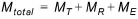
If, on the other hand, the air temperature is below the threshold melting temperature, then the dry snow storage will be increased (wet snow converted to dry snow) by combining the freezing rate and the radiation melting rate, until the wet snow storage goes to zero
(22.9) 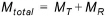
In this case, the temperature melting will be positive (i.e. freezing) and radiation melting will be negative.
![]()