
This tool has been implemented to transform MIKE 21 grid data files into ASCII data in ESRI’s Grid format.
Note: Import of raw ASCII data as a layer using ‘Add Data’ in ArcGIS may result in a misleading color ramp. Optionally use instead
ArcGIS Toolbox->Conversion->To Raster->ASCII to Raster.
Note: This tool only works correctly with a grid-orientation of 0 deg.N and a grid spacing that is the same in both X- and Y-direction.
An example of ESRI’s ArcView Grid Ascii format is shown below.
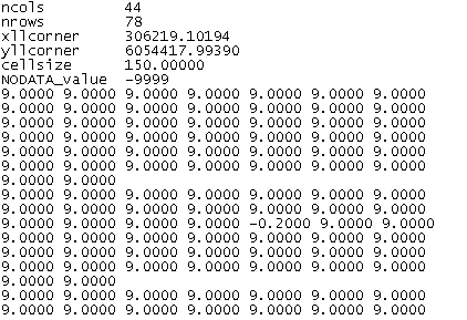
Figure 11.1 Example of resulting asc file. Only part of file (the top) is shown)
![]()