
The MIKE 21 multi-cell overland solver is designed for simulating two-dimensional flow in rural and urban areas. The overall idea behind the solver is to solve the modified equations on a coarse grid taking the variation of the bathymetry within each grid cell into account. Results are presented on the grid that takes the fine scale bathymetry into account. When using the multi-cell overland solver the HD result files will also inherit the geographical information from the fine scale bathymetry.
Please note that even though results are presented on the fine scale, the numerical simulations are carried out on a higher scale. The inundation is calculated based on a depth varying flooded area.
To run the multi-cell overland solver the solver must be selected (see Figure 4.1) along with the fine bathymetry file (in dfs2 format).
that only valid dsf2 files may be selected. If the overland solver has been selected the Coriolis forcing will be deactivated along with the land slide option.
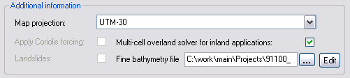
Figure 4.1 The selection of the multi-cell overland solver
See also Multi-cell overland Solver (p. 109).
![]()