In addition to the bathymetry for your model area the following area information should also be specified:
· The initial surface elevation in the area. Because the model initialises the fluxes or current velocities to zero, you must specify an initial surface elevation that is in agreement with these conditions. In practice this means that you should specify a value that matches the boundary conditions at the first time step. If the model area is large and the surface levels at the open boundaries differ substantially, you should create a data file with an initial surface elevation at each grid point. However, in most cases you can just use the average surface elevation at the open boundaries.
· The latitude and longitude at the lower left corner of the model should be provided through the bathymetry data file. In dfs2 data files there is a possibility to store information about the applied projection zone (e.g. UTM-32), and this information is used as the default projection zone. The user may choose to overwrite the default projection zone. If no geographical information is available through the bathymetry data file or if the projection zone “Local coordinates” is chosen, then Coriolis forcing is not applied.
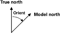
· The orientation of your model (also provided in the bathymetry data file). This is defined as the angle between true north and the y-axis of the model measured clockwise. A mnemonic way of remembering this definition is by thinking of NYC, which normally means New York City, but which for our purpose means “from North to the Y-axis Clockwise”, see Figure 6.10.
Figure 6.10 Definition of model orientation
· A value representing land (provided in the bathymetry data file, see below). This means that all grid points with a depth value equal to or greater than the value you specify will always be considered to be land and will not be subject to possible flooding and drying.
· Flooding and drying parameters. Please refer to Flooding and Drying (p. 104) for a detailed description of this facility.

Please note: Bathymetry data files must contain a custom block called M21_Misc which consists of 7 elements of type float:
· The first element is the orientation.
· The third element is a flag and the value -900 indicates that the data file contains geographic information.
· The fourth element is the value representing land.
· The rest of the elements are not used in bathymetry data files.