Constructing the fine and the coarse bathymetries
To apply the multi-cell overland solver two bathymetries must be constructed
· A bathymetry with a coarse resolution which defines the calculation grid and the location of boundary conditions
· A fine resolution bathymetry which is used for result presentation and evaluation of hydraulic parameters within a coarse grid cell
The two bathymetry must obey a number of rules
1. The extent of the bathymetries must be identical.
2. The number of grid cells in the J and the K direction for the fine grid must be dividable by the number of cells in the J and K direction respectively in the coarse grid i.e. the number fine grid cells within a coarse grid cell must be integer.
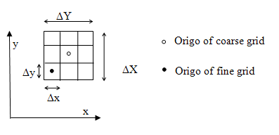
The first of these points may at first glance easy to satisfy simply by ensuring that the two bathymetries have the same origo and the same length in the X and the Y direction. A word of caution is in order here. The origo of a dfs2 file which has a true projection such as a UTM type associated with it refers to the centre of the cell (j,k)=(0,0). The situation is illustrated in Figure 6.16.
Figure 6.16 The location of the origo of the coarse and fine grid when a true projection is applied.
The Origo of the fine grid should be placed according to
(6.16) 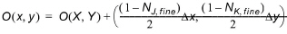
where the capitalized X and Y refer to the origo of the coarse grid and NJ,fine and NK,fine refer to the number of fine grid cells within a coarse grid cell in the J and K direction respectively.
As a rule of thumb the difference in grid size should be not be higher than a factor 4 to 5.
Along the boundaries the topography from the coarse grid is used i.e. the bathymetry in the fine grid is modified to be equal to the coarse grid at boundaries. To ensure stability is recommended to smooth out the bathymetry of the fine grid close to boundaries to avoid sudden changes in the water depth.
True land points are defined by the coarse grid and any land points will be transferred to the fine bathymetry at run time.

Note: All values in the fine bathymetry must be lower than the specified land value in the coarse bathymetry.
![]()