Evaluation of hydraulic parameters within a cell
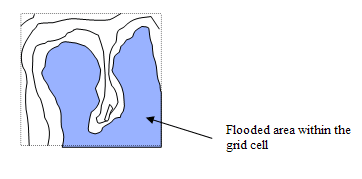
The methodology adapted for the multi-cell overland solver requires an evaluation of the hydraulic parameters such as the flooded area within a grid cell. The flooded area within a grid cell is illustrated in Figure 6.17.
Figure 6.17 The flooded area is a function of the surface level within a grid cell.
The calculation of the flooded area, hydraulic radius, flow area within a cell etc. may be a time consuming process. For this reason MIKE 21 evaluates these parameters at a number of levels within each cell in a preprocessing initialisation phase. The calculated parameters are stored in three dimensional arrays (in memory) which are subsequently used at each time step in the simulation.
By default MIKE 21 calculates the parameters at 100 equidistant levels between the highest and the lowest point within each cell. The number of levels may be adjusted through the adding an optional parameter in the hydrodynamic section of the input file. The parameter is termed Number_Levels_Overland.

Note that the higher this value is, the greater the amount of memory is reserved for processed data. On the other hand if the value is too small the variation of the topography within a grid cell will not be sufficiently resolved. The number should reflect the variability within one coarse grid cell.
![]()