Although the selection of the grid spacing and of the model area are closely connected there are a number of special considerations (as listed below) which you have to make when selecting the grid spacing. Except for the first one and the last one they are all related to the Courant number and thus the speed with which the information travels in the model. Please see Courant Number (p. 98) for a description of these terms.
· First of all your grid should resolve all the variations in the bathymetry which are important for the flow you wish to simulate.
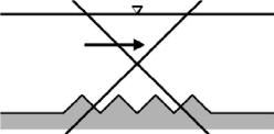
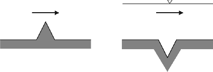
· MIKE 21 will probably not become unstable if you have an isolated bump or hole in your bathymetry (provided that it is not close to a boundary), see Figure 6.4. However, a series of bumps and holes along a grid line might lead to instabilities if the flow direction is parallel to this grid line and the Courant number is greater than 1, see Figure 6.5.
Figure 6.4 Unwise bathymetric resolution
Figure 6.5 Unstable bathymetric resolution for Courant numbers greater than 1
· If you cannot avoid channels which run at an angle of 45 degrees to the grid, the grid spacing and time step should be chosen as shown in Figure 6.6.
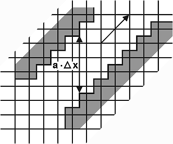
Figure 6.6 Flow in a channel at 45 degrees
· Closely related to the condition above is the treatment of deep channels in shallower areas. When you model an area with narrow and deep channels it is quite normal that the channels are only one or a few grid points wide. You should, however, take care when the narrow channels cross from one grid line to the next. If the flow in the channel is of importance the number of overlapping grid points should be greater than the local Courant number. This will ensure that the flow information is transferred properly up the channel, see Figure 6.7.
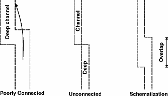
Figure 6.7 Schematisation of a narrow channel
· You should avoid alternating land-water-land-water boundaries as shown in Figure 6.8 if the Courant number is larger than 1.
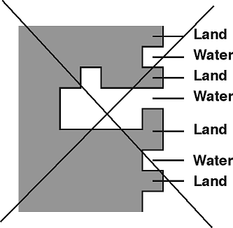
Figure 6.8 Schematisation of land, which should be avoided
Areas that are subject to flooding and drying should not be made completely level but given a gentle slope towards the nearest area with deep water. This will ensure that a series of one point ponds is not left in the otherwise dry areas when the water withdraws.
![]()