Routing branches does not per default consider any water levels as the primary purpose is to route a hydrograph through the river system and hence, only the discharge is a key state variable. It is, however, possible to determine water levels in case this should be necessary for specific applications (e.g. coupling of MIKE HYDRO to MIKE SHE where head elevations are essential to calculate the correct discharge/recharge interaction between surface and sub-surface water).
Two methods are available for Water level calculations:
· Rating curve approach (Q-h table)
Both apply for steady-state flow and are thus approximations, but they are usually reasonable estimates as long as the water level does not change rapidly (e.g. during a flood). The items in the dialogue window change depending on the option chosen.
When the Rating Curve approach is used, it looks up the water level in a user specified Q-h table. The table must cover the range of discharges encountered during a simulation.
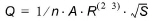
Where n is the Manning’s number n, A is the cross-sectional area, S is the water surface slope, R is the hydraulic radius or resistance radius:
The hydraulic parameters in river modelling are required and consequently, it is required to specify cross sections in the routing branch in order to extract hydraulic parameters from the processed data. If cross sections does not exist, it is not possible to use the Manning formula option.
![]()