This section offers available options for interpolating values onto the grid or mesh. These include:
· Copy value from nearest scatter point. In this option, mesh node values are simply taken from the nearest scatter point (i.e. from active input topographical layers). This option can dramatically decrease interpolation time when a very dense set of scatter data points is available. This is because values are simply set from the nearest scatter points, and true interpolation is only performed for areas where scatter points are beyond the search radius. Mesh node points assigned a value in this way will not be included in the overall interpolation.
The search radius from a mesh node to the nearest scatter point is set via the ‘Interpolation beyond search radius’ parameter. Set a reasonable search distance based on scatter data resolution.
· Method. The available interpolation methods are:
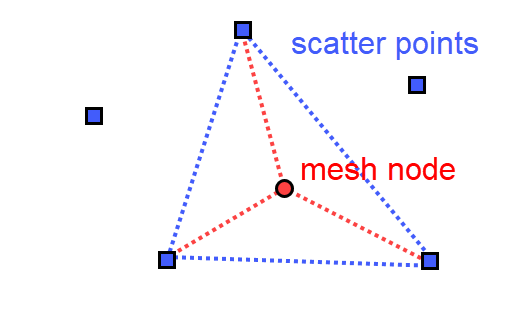
- Linear Interpolation. For each mesh node to be interpolated, a surrounding triangle based on scatter points is determined, and a linear interpolation based on the scatter point values is made.
Figure 3.19 Illustration of the linear interpolation method for deriving topography values for mesh nodes from input scatter points
- Natural neighbour interpolation. Is a geometric estimation technique that uses natural neighbourhood regions generated around each node. The natural neighbourhood regions are determined by creating a triangulated irregular network from the scatter data points. It is particularly effective in dealing with a variety of spatial data themes exhibiting clustered or highly linear distributions.
Natural neighbour method extrapolation beyond the extent of the scatter data may be enabled and controlled through the ‘Extrapolate to ...% beyond envelope of scatter data’ parameter.
The points will be placed at the lower left, upper left, lower right and upper right corner of the workspace area, respectively. The parameter specifies the distance from the four points to the data extent area. The water depth value at the four points will be defined as the extrapolation value.
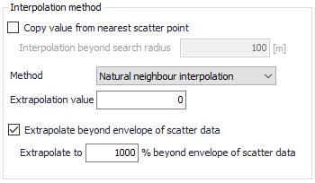
Figure 3.20 Natural neighbour interpolation parameters
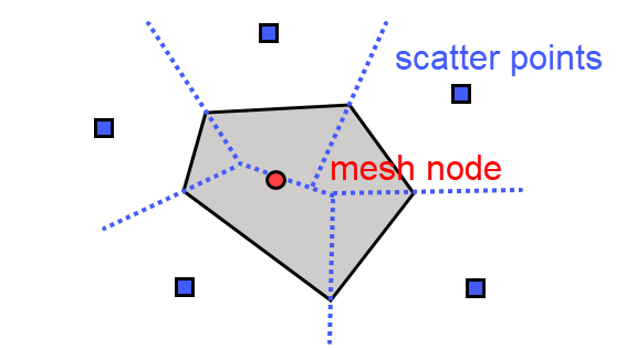
Figure 3.21 Illustration of the natural neighbour interpolation method for deriving topography values for mesh nodes from input scatter points
· Extrapolation value. Specify a value to be used when the program needs to extrapolate values beyond configured interpolation settings in the model.
![]()