A coastline bathymetry is described by a combination of conditions along the coastline and conditions across the coastline. The conditions across the coastline are specified by one or a number of cross-shore profiles (see 5.3.2 Profile (p. 74)).
In this dialogue you have to specify the conditions in the longshore direction. You have to specify conditions for the following:
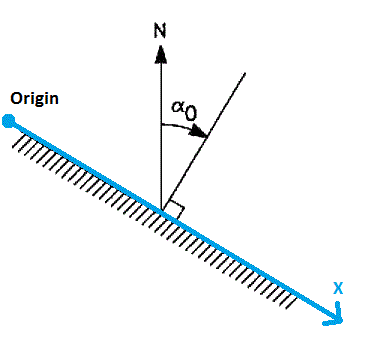
The description of the coastline is defined relative to a baseline, which has to run parallel to the general orientation of the coastline in question. The line series file for the shoreline position contains information about the geographical position and the fixed orientation of the baseline (normal to the baseline). Per default the coastline orientation is derived from the line series file, but you have the option to modify this.
Figure 5.5 Definition of coastline orientation and baseline alignment

The orientation of the coastline is defined as 90 degrees counter-clockwise to the direction of the actual line series.
The orientation at the origin refers to the ‘True North’ direction.
![]()