For each item in the Postprocessing list above, a new item will be added to the data tree. If you expand the data tree, each will have the following dialogue.
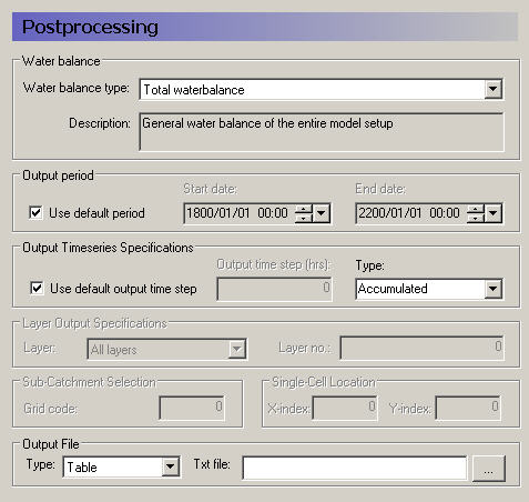
Water Balance
Multiple postprocessings can be run on each water balance extraction. More detail on the types of available water balances data are discussed in the Standard Water Balance Types (V1 p. 128) section. In brief, the available types include
· The total water balance of the entire model catchment or sub-catchments in an ASCII table, a dfs0 file, a dfs2 map file, or a graphical chart (also by layer),
· Model errors for each hydrologic component (overland, unsaturated zone, etc.) in an ASCII table, a dfs0 file, or a dfs2 map file (also by layer),
· The snow melt and canopy/interception water balance in an ASCII table, or a dfs0 file,
· An abbreviated or detailed water balance for overland or unsaturated flow in an ASCII table, or a dfs0 file, and
· An abbreviated or detailed water balance by layer for saturated flow in an ASCII table, or a dfs0 file.
Output Period
An output period different from the total simulation period can be specified by unchecking Use default period and setting the Start date and End date to the period of interest
Output time series Specification
Incremental or Accumulated water balances can be calculated. An incremental water balance is calculated (summed) for each output time step in the Output period. An accumulated water balance each output time step is accumulated over the Output period
Layer Output Specifications
If you are using water balance types that calculate data on a layer basis, you can specify whether you want All layers or just the Specified layer, where you also must specify a layer number.
Sub-catchment Selection
If you extracted sub-catchment data from the WM results, then you must specify a subcatchment number or the name of the polygon for which you want the water balance for. The combobox contains a list of valid ID numbers or polygon names.
Single Cell Location
If you extracted the WM data by cell, then if you are not creating a map output, then you have to specify a cell location for which you want a water balance.
Output File
If you are creating a table or time series water balance, then you can write the output to either a dfs0 file or to an ASCII file for import to MSExcel, or other post-processing tool. If you are creating a map, then the output will be to a dfs2 file, with the same grid dimensions and spacing as the model grid. If you are creating a chart, then the output will be written to an ASCII file, with a special format for creating the graphic.
Related items
· Using the Water Balance Tool (V1 p. 95)
![]()