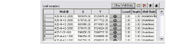
Well_ID - This is the user specified name of the well. The Well_ID cannot contain any spaces.
X, Y - These are the X and Y map coordinates of the well.
EUM Data Units: Item geometry 2-dimensional
Level - The Level defines the maximum elevation shown on the profile view of the geologic layers, calculation layers, and screened intervals for the well. The topography is shown if the Level is less than the topography.
EUM Data Units: Elevation
Depth - The Depth is defined from the Level. It defines the maximum depth shown on the graphical view displaying the profile view of the geologic layers, calculation layers, and screened intervals for the well. The bottom of the geologic layers is shown if the Level minus the Depth is higher than the bottom of the geologic layers.
EUM Data Units: Depth below ground
Well Field - The Well Field item is used for filtering the displayed boreholes. The Mask item in the top menu bar uses the Well Field for it selection criteria. The Well Field item is also used to defined registration zones in the Random Walk Particle Tracking (PT) module. For more information, see Particle Tracking (PT) (V1 p. 727), and Particle Tracking-Reference (V1 p. 723).
![]()