The main idea behind the 2D, multi-grid solver is to make the choice of calculation grid independent of the topographical data resolution. The approach uses two grids:
· One describing the rectangular calculation grid, and
· The other representing the fine bathymetry.
The standard methods used for 2D grid based solvers do not make a distinction between the two. Thus, only one grid is applied and this is typically chosen based on a manageable calculation grid. The available topography is interpolated to the calculation grid, which typically does not do justice to the resolution of the available data. The 2D multi-grid solver in MIKE SHE can, in effect, use the two grids more or less independently.
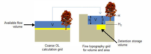
In the Multi-cell overland flow method, high resolution topography data is used to modify the flow area used in the St Venant equation and the courant criteria. The method utilizes two grids - a fine-scale topography grid and a coarser scale overland flow calculation grid. However, both grids are calculated from the same reference data - that is the detailed topography digital elevation model.
In the Multi-cell method, the principle assumption is that the volume of water in the fine grid and the coarse grid is the same. Thus, given a volume of water, a depth and flooded area can be calculated for both the fine grid and the coarse grid. See Figure 25.1.
In the case of detention storage, the volume of detention storage is calculated based on the user specified depth and OL cell area.
During the simulation, the cross-sectional area available for flow between the grid cells is an average of the available flow area in each direction across the cell. This adjusted cross-sectional area is factored into the diffusive wave approximation used in the 2D OL solver. For numerical details see Multi-cell Overland Flow Method (V1 p. 472) in the Reference manual.
The multi-grid overland flow solver is typically used where an accurate bathymetric description is more important than the detailed flow patterns. This is typically the case for most inland flood studies. In other words, the distribution of flooding and the area of flooding in an area is more important than the rate and direction of ingress.
Figure 25.1 The constant volume from the coarse grid is transferred to the fine scale grid
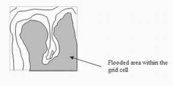
Figure 25.2 Flooded area is a function of the surface water level in the grid cell.
Elevations
The elevation of the coarse grid nodes and the fine grid nodes are calculated based on the input data and the selected interpolation method. However, the coarse grid elevation is adjusted such that it equals the average of the fine grid nodal elevations. This provides consistency between the coarse grid and fine grid elevations and storage volumes. Therefore, there may be slight differences between the cell topography elevations if the multi-cell method is turned on or off. This could affect your model inputs and results that depend on the topography. For example, if you initial water table is defined as a depth to the water table from the topography.
![]()