The dike data are defined in two grid tables in the present page:
Upper input data grid and Lower input data grid.
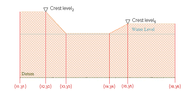
Figure 5.6 Example of dike defined by 6 geo-referenced points
The number of dikes must be defined initially. This number defines the number of structure definition lines which will be present for defining the dike input data.
Name
Include
Location
Discharge coefficient
Delta level
Crest level information
The Name of dike is a user defined ID-string for each dike.

Note: Names must not be identical for different structures included in the model simulations.
It is possible to include or exclude defined dikes from the simulation.
'Location' and 'Projection' columns define the actual location of the dike.
The location in the horizontal domain of a dike is given by a number of geo-referenced points which together make up a polyline. The geographical coordinates are defined in the Lower input data grid shown when pressing the  button in the 'Location' column. You must also select the map projection (Longitude/Latitude, UTM etc.) in which the specified location coordinates for the dike are defined.
See also Location of a structure (p. 125).
For a description of the discharge coefficient see Dikes (p. 132).
When the water level gradient across a structure is small, the corresponding gradient of the discharge with respect to the water levels is large. This in turn may result in a very rapid flow response to minor changes in the water level upstream and downstream.
As a way of controlling this effect, a critical level difference has been introduced. The critical water level difference defines the water level difference below which the discharge gradients are suppressed. The default setting is 0.01 meter. If a structure shows oscillatory behaviour it is recommended to increase this value slightly.
The crest level of the dike can be specified as
· Constant
· Varying in space
· Varying in space and time
When Constant is specified you have to specify the constant crest level. In case the crest level is varying you have to specify the crest level data in the Lower input data grid for the defined grid points.
The location in the horizontal domain of a dike is given by a number of geo-referenced points which together make up a polyline. The poly-line defines the width of the dike perpendicular to the flow direction. A minimum of two points is required. The polyline is composed of a sequence of line segments. The line segments are straight lines between two successive points. The polyline (cross section) in the numerical calculations is defined as a section of element faces. The face is included in the section when the line between the two element centres of the faces crosses one of the line segments.
The geo-referenced points defining the dike can be specified directly in the dialog or imported from an ASCII file. The file format is three space separated floats (real numbers) for the x- and y-coordinate and the crest level on separate lines for each of the points.

Note:The faces defining the line section for the dike will be listed in the log-file.
The crest level of a dike can be specified as:
· Constant
· Varying in space
· Varying in space and time
When the crest level is specified as constant the crest level is defined by the value specified in the Upper input data grid.
When the crest level is specified as varying in space the crest level is defined by the values in the Lower input data grid.
When the crest level is specified as varying in space and time you have to prepare a data file containing the crest level before you set up the simulation. The file must be a dfs1 file, where the number of grid points corresponds to the number of points, which is used to define the location of the dike. The data must cover the complete simulation period. The time step of the input data file does not, however, have to be the same as the time step of the hydrodynamic simulation. A linear interpolation will be applied if the time steps differ.
![]()