|
Overland Flow Zones |
|
|---|---|
|
Conditions: |
If Overland Flow + the Subcatchment-based method is chosen in the Simulation Specification dialogue |
|
dialogue Type: |
Integer Grid Codes with sub-dialogue data |
|
Grid Code |
|
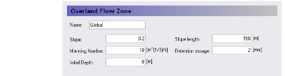
The Overland flow zones are used to defined the topographic zones for the simple, catchment-based overland flow solution. The overland flow zones are typically defined as areas with similar topography. For example, the river flood plain would be a typical topographic zone, although it might be included in many subcatchments.
Each unique grid code in the Overland Flow Zones map will generate a sub-item in the data tree where the following parameters must be specified.
Slope - The Slope variable is a representative slope in the topographic area. It can be thought of as the average slope, but it is really a calibration parameter as it can’t really be calibrated to a true average.
Slope Length - Like the Slope itself, the Slope Length is a representative distance that water must travel as overland flow before reaching a ditch or stream. It can be thought of as the average travel distance, but, like the Slope, it is really a calibration parameter as it can’t really be calibrated to a true average.
Manning Number - The Manning M is equivalent to the Stickler roughness coefficient. The Manning M is the inverse of the more conventional Mannings n. The value of n is typically in the range of 0.01 (smooth channels) to 0.10 (thickly vegetated channels). This corresponds to values of M between 100 and 10, respectively. Generally, lower values of Mannings M are used for overland flow compared to channel flow.
Detention Storage - Detention Storage is used to limit the amount of water that can flow over the ground surface. For example, if the detention storage is set equal to 2mm, then the depth of water on the surface must exceed 2mm before it will be able to flow as overland flow. Water trapped in detention storage continues to be available for infiltration to the unsaturated zone and to evapotranspiration. Using detention storage, you can simulate water that is trapped in depressions that are smaller in area than a grid cell.
Initial Depth - This is the initial condition for the overland flow calculations, that is the initial depth of water on the ground surface.
Related Items:
· Simplified Overland Flow Routing (V1 p. 476)
· Overland Flow - Technical Reference (V1 p. 459)
· Working with Overland Flow and Ponding- User Guide (V1 p. 483)
![]()