|
Soil Profile Definitions |
|
|---|---|
|
Conditions: |
when Unsaturated Flow selected in the Simulation Specification dialogue and Richards Equation or the Gravity Flow module selected for the numeric engine |
|
dialogue Type: |
Integer Grid Codes with sub-dialogue data |
|
Grid Code |
|
The first part of the soil profile definition is to define the areas with the same soil profiles. This can be done using either a uniform value or distributed using a dfs2 integer grid code file or a polygon .shp file. For each unique grid code or polygon in the distribution file, a separate sub-item will appear in the data tree, in which you can define the soil profile data.
In the sub-item dialogues, the soil type and distribution of the soil layers (i.e. depth and thickness of each soil type) in the individual profiles is specified, as well as the vertical discretisation of the soil profile.
Definition of soil properties
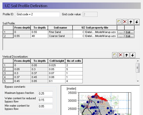
Profile ID - This is the editable name displayed in the data tree for this profile.
Grid code value - This is the current integer grid code or polygon value read from the soil distribution.
Soil Profile - The soil profile section allows you to define the vertical soil profile. Soil layers can be added, deleted and moved up and down using the icons.
From and To Depths refers to the distances to the top and bottom of the soil layer, below the ground surface. Only the To Depth item is editable, as the From Depth item is equal to the bottom of the previous layer.
Soil name is the name of the soil selected in the UZ Soil Property file. It is not directly editable, but must be chosen from the list of available soil names when you assign the UZ Soil property file using the file browser.
UZ Soil property file is the file name of the soil database, in which the soil definition is available. The Edit button opens the specified Soil property database file, whereas the Browse button [...] opens the file browser to select a file.
Vertical discretisation - In this section you specify the vertical discretisation of the soil profile, which typically contains small cells near the ground surface and increasing cell thickness with depth. However, the soil properties are averaged if the cell boundaries and the soil boundaries do not align.
From and To Depths refers to the distances to the top and bottom of the soil layer, below the ground surface. Neither are directly editable since they are calculated from the number of cells and their thicknesses.
Cell Height is the thickness of the numerical cells in the soil profile.
No. of Cells is the number of cells with the specified cell height. Together these two values define the total thickness of the current section.
Dispersivity is the longitutinal dispersivity in the column. This column only appears if WQ is simulated in the unsaturated zone.
The discretisation should be tailored to the profile description and the required accuracy of the simulation. If the full Richards equation is used the vertical discretisation may vary from 1-5 cm in the uppermost grid points to 10-50 cm in the bottom of the profile. For the Gravity Flow module, a coarser discretisation may be used. For example, 10-25 cm in the upper part of the soil profile and up to 50-100 cm in the lower part of the profile.
Note that at the boundary between two blocks with different cell heights, the two adjacent boundary cells are adjusted during the pre-processing to give a smoother change in cell heights.
Bypass Constants The bypass constants are editable when Simple Bypass flow is checked on in the main Unsaturated Zone (V1 p. 282) dialogue. The availabe bypass parameters include:
Maximum bypass fraction - This is the maximum fraction of net rainfall that will infiltrate via simple macropore flow. Valid values are between 0 and 1.0.
Water content for reduced bypass flow - This is the threshold water content below which the bypass fraction is reduced. If the water content 10cm or 50cm below the ground surface is less than this water content, then the soil is dry and the bypass flow will be reduced.
Limit on water content for bypass flow - This is the minimum water content for bypass flow. If the water content 10cm or 50cm below the ground surface is less than this limit, then the soil is very dry and the bypass flow will be zero.
The actual relationship between the bypass constants and the calculation of the bypass flow is described in Simplified Macropore Flow (bypass flow) (V1 p. 564).
Related Items:
· Unsaturated Zone - Technical Reference (V1 p. 549)
· Richards Equation (V1 p. 550)
![]()