Spatially distributed Real parameters, such as conductivity or topography, can be defined in three ways, namely they can be defined as a uniform (global) value or they may be distributed and defined using either gridded data (.dfs2 file), GIS points and polygons (ArcView .shp file), or irregularly distributed point data (x, y, value coordinate file).
It does not make sense to interpolate some parameters to the model grid. In such cases, the use of line and point data should be avoided.
Uniform
A uniform, global value means that all the grid cells in the model will have the same value.
GIS point and line data or Distributed point data
If the parameter is defined using irregularly distributed point data or an ArcView shape (.shp) file, then the data will be interpolated to the model grid during the pre-processing stage, using the interpolation method selected.
The following interpolation methods are included:
· Bilinear Interpolation (V1 p. 161), or
· Triangular Interpolation (V1 p. 164)
· Inverse Distance Interpolation (V1 p. 165).
It does not make sense to interpolate some parameters to the model grid. In such cases, the use of line and point data should be avoided.
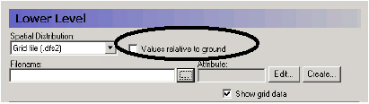
Elevation data, such as Layer elevations, is handled exactly the same as all other Stationary Real Parameters, except that the value may be optionally specified as a depth below the ground surface rather than absolute elevation above the datum.

Note: The value must be negative if it is below the ground level.

Tip: The current tools do not allow you to specify a polygon shape file with real values. However, this would be desirable in some cases, such as when implementing Manning’s M values based on vegetation distributions. A trick to get around this limitation is the following:
1. Temporarily assign an integer grid code to each of the polygons.
2. Specify this file as an input file for one of the data items that needs integer grid codes, such as drain codes.
3. Right click on the map that will be displayed and save the map view to a dfs2 file
4. Open this dfs2 file in the grid editor and use the grid editor tools to replace the integer values with real values
5. In the Grid Editor, change the EUM unit to the appropriate value
6. Save the file and then load it into the Data item for which you wanted it.
![]()